


This week's weather is unpredictable! Wu Derong forecasts that there will be short waves passing through on Thursday and Saturday, so be aware of severe weather.
讀後心得
The latest European model shows that there will be significant rainfall near Taiwan on Thursday morning (the 10th), followed by a second wave of short waves passing through next Sunday (the 13th), resulting in increased precipitation across the island. According to meteorological expert Wu Derong's forecast, the cloud system in South China will move eastward from today to tomorrow, with more cloud cover, but the area of rainfall will shrink, and there will still be a chance of localized brief rain in the north and east. Daytime temperatures across the island will range from 14 to 24 degrees in the north, 16 to 27 degrees in the central region, 18 to 30 degrees in the south, and 16 to 28 degrees in the east. On Tuesday and Wednesday, the weather will improve slightly during the day, with temperatures rising, but on Thursday, the first wave of short waves will affect the area, leading to unstable weather. Then, on Friday, the short wave will move away, and the weather will improve again. Overall, the forecast indicates that the first wave of short waves may bring heavy rainfall and thunderstorms, and future simulations are still being adjusted and will require continued attention.
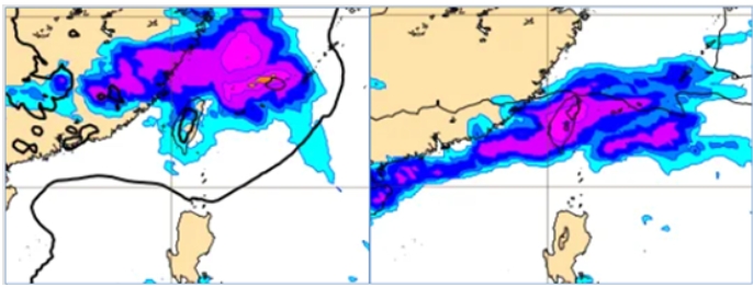
The latest (October 5 at 20:00) European model (ECMWF) shows that at 8:00 on Thursday (October 10), the surface pressure and precipitation simulation map (left image) indicates that the first wave of short waves will pass through, causing significant precipitation near Taiwan. The simulation map for 8:00 next week (October 13) (right image) shows that with the arrival of the second wave of short waves, there will be widespread significant rainfall across the island.
According to meteorological experts' analysis, from today until tomorrow, the South China cloud system will move eastward and weaken, with a considerable amount of cloud cover remaining in various areas, and the range of rainfall will gradually shrink. Although there is still a chance of localized short-term rain in mountainous areas and the northern and eastern regions, the overall weather forecast predicts comfortable conditions in the north, warm and slightly cooler in the mornings and evenings in the south. Temperature forecasts are as follows: North 14 to 24 degrees, Central 16 to 27 degrees, South 18 to 30 degrees, and East 16 to 28 degrees.
On Tuesday and Wednesday, the weather will improve across the regions during the day, with a brief break in rainfall, leading to a rise in temperatures. There may occasionally be short-lived light rain in mountainous areas. As the first wave of short waves passes on Wednesday night and Thursday, the weather will once again become unstable, and temperatures will slightly decrease. By Friday, as the short wave dissipates, a break will reappear, improving the weather and accompanied by rising temperatures. As for Saturday and next Sunday, the passage of the second wave of short waves will once again trigger unstable weather, and temperatures will decrease again. By next Monday and Tuesday (October 14 and 15), as the short waves move away, the weather will improve and temperatures will rise again.
When the short waves pass, convective precipitation may occur, accompanied by thunderstorms, strong winds, and extreme weather conditions such as sudden heavy rainfall; however, regarding the specific timing of the short wave passage and the intensity of convection, model simulations are still being adjusted, requiring continuous monitoring.