


Rainfall Weakens! This week features alternating sunshine and rain, with "two short weather systems" bringing drastic changes in weather.
讀後心得
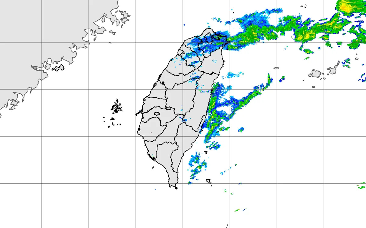
The Meteorological Administration has issued a heavy rain special report. Due to the influence of the South China cloud system, there is a possibility of localized heavy rain in the Nantou and Hualien mountainous areas, and citizens are reminded to pay attention to the risks of landslides and falling rocks. Today, there will be brief rainfall in the western mountainous areas and eastern regions, with the north being mostly cloudy with sporadic brief rain. In terms of temperature, the north will be cooler in the morning, with daytime highs ranging from 21 to 25 degrees in the north and 26 to 28 degrees in the central and southern regions, reflecting a significant temperature difference between the north and south. As for the weather in the outlying islands, Penghu, Kinmen, and Matsu will also experience varying degrees of overcast skies and temperature changes. Associate Professor Wu De-Long stated that the cloud system will gradually weaken, and temperatures will rise slightly across the region. The weather is expected to improve from Tuesday to Wednesday, but there may be unstable weather on Thursday. The Meteorological Administration reminds that there is a chance of strong winds in coastal areas from this afternoon into the evening, and low clouds or fog may occur in the Matsu region, affecting visibility.
Under the influence of the Huannan cloud system, there is a possibility of localized heavy rain in the mountainous areas of Nantou and Hualien. (Image: Meteorological Administration website) The Meteorological Administration has issued a heavy rain alert, indicating that today (the 6th) there may be localized heavy rain in the mountainous areas of Nantou and Hualien, urging the public to be cautious of landslides and falling rocks.
The Meteorological Administration stated that today, localized brief showers are expected in the western half of the mountainous areas, the eastern half of the region, and the Hengchun Peninsula. The northern part will have more cloud cover, with occasional brief showers, while the central region may experience scattered showers from early morning to noon, and other areas will mainly be partly cloudy to sunny.
Regarding temperatures, the northern and northeastern parts will feel slightly cool in the early morning, with lows around 16 to 17 degrees Celsius; the central region and Hualien will have lows around 17 to 18 degrees; the southern part and Taitung will have lows between 19 to 21 degrees. During the day, the northern and eastern parts will have more clouds, with high temperatures ranging from 21 to 25 degrees, while the central and southern regions are expected to have high temperatures between 26 to 28 degrees. There will be a greater temperature difference between the north and south, so travelers moving between the two should be mindful of temperature changes.
As for the weather on the outlying islands: Penghu will be mostly sunny with cloud, with temperatures ranging from 19 to 24 degrees; Kinmen will see clouds with occasional sunshine, with temperatures from 17 to 25 degrees; and Matsu will have mostly sunny weather with clouds, with temperatures from 15 to 20 degrees.
An associate professor from the Department of Atmospheric Sciences at National Central University pointed out that from today to tomorrow, the Huannan cloud system will move eastward and gradually weaken, while there will still be relatively more clouds in various regions, and the scope of rain will gradually shrink. There is still a chance of localized brief showers in the mountainous areas, as well as the northern and eastern parts; temperatures are expected to slightly rise each day. Today's daytime temperatures will still be comfortable in the north and slightly warm in the south, with cooler conditions felt in the early morning and evening.
The expert reminded that the weather will improve during the day on Tuesday and Wednesday, allowing for a brief respite, with temperatures rising; however, there is still a chance of occasional localized brief showers in the mountainous areas. It is anticipated that the first wave of short waves will arrive on Wednesday night and Thursday, making the weather unstable and causing a slight drop in temperatures; on Friday, the short waves will move away, the weather will improve, and temperatures will rise again; on Saturday and next Sunday, the second wave of short waves will arrive, causing the weather to become unstable again and a slight temperature decrease; after the short waves move away on next Monday and Tuesday, the weather will improve, and temperatures will rise again.
Typically, when short waves pass, they are accompanied by convective precipitation, and there may be occurrences of "severe weather" conditions such as thunderstorms, strong winds, and sudden heavy rain. However, the timing and intensity of the convection during the passage of short waves are still being adjusted and require continuous monitoring.
The Meteorological Administration reminds that from this afternoon to evening, there is a probability of localized average wind speeds reaching level 6 or above, or gusts reaching level 8 or above, in Taichung, Changhua coastal areas, Hengchun Peninsula, as well as Penghu, Green Island, and Lan Yu; the public should be cautious. In addition, starting today, the Matsu area may also experience localized low-lying clouds or fog, affecting visibility; travelers should pay attention to flight information.