


This week's weather changes frequently! Wu Derong forecasts that a short-term weather system will strike on Thursday and Saturday, so attention is needed for severe weather.
讀後心得
The latest European weather model indicates that Taiwan will experience significant precipitation on Thursday (10th) morning, especially during the passage of the first short wave. A second short wave is expected to impact on Sunday (13th), bringing rain across the island. From today until tomorrow, the cloud system from South China will gradually weaken, although there will still be a chance of localized brief rain, and temperature changes will also be noticeable. Weather will improve on Tuesday and Wednesday, with a reduced probability of brief rain. After Friday, the weather will improve again, but the subsequent short wave will bring unstable weather and precipitation. Future rainfall timing and intensity will need to be continuously monitored.
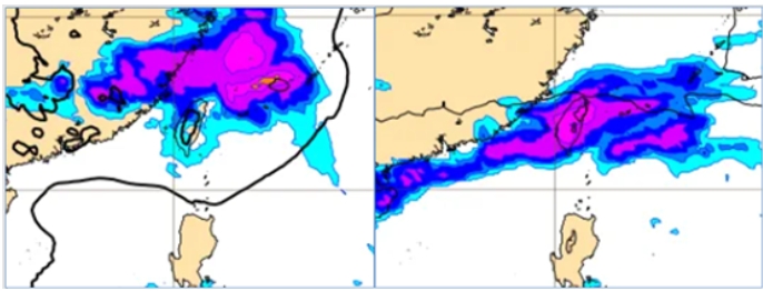
The latest European model (ECMWF) shows that at 8 AM on Thursday (10th), the ground pressure and precipitation simulation indicates significant precipitation is expected near Taiwan with the passage of the first wave of short waves. As for the simulation at 8 AM next week (13th), the second wave of short waves will also pass through, and noticeable precipitation is anticipated across the entire island.
According to meteorological experts' analysis, from today until tomorrow, the South China cloud system will move eastward and weaken, with cloud cover remaining relatively high across various regions. The range of rainfall will gradually diminish, but there is still a possibility of localized light brief rain in mountainous areas and the northern and eastern parts. Today's daytime temperature forecasts are: 14 to 24 degrees in the north, 16 to 27 degrees in the central region, 18 to 30 degrees in the south, and 16 to 28 degrees in the east.
On Tuesday and Wednesday daytime, the weather will improve in various regions, providing short temporary breaks, and temperatures will rise again; mountainous areas may occasionally experience localized brief rain. As for Wednesday night and Thursday, the passage of the first wave of short waves will bring unstable weather, with a slight decrease in temperature. By Friday, the short wave will move away, and meteorological conditions will improve once again, resulting in a temperature rise.
On Saturday and next Sunday, with the passage of the second wave of short waves, the weather will become unstable again, with a slight decrease in temperature. By next Monday and Tuesday (14th, 15th), after the short waves have moved away, the weather will shake off instability and temperatures will rise again. During the passage of the short waves, convective precipitation is expected, accompanied by thunderstorms, strong winds, and sudden heavy rain, reflecting "severe weather" phenomena. However, the timing of the short wave passage and the intensity of convective activity will need further observation of the model adjustments.