


High temperatures soar to 30 degrees, and weather changes are about to arrive! Remember to bring an umbrella when you go out. Let's take a look at the latest weekly weather forecast.
讀後心得
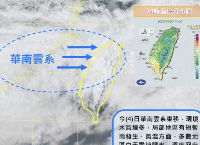
This week's weather forecast shows that Monday will be cool, with temperatures reaching a maximum of 39 degrees. Two fronts will hit on Wednesday and over the weekend, so be sure to keep warm and carry rain gear. There will be localized brief rains in various regions, with temperatures ranging from 17 to 28 degrees in the north, 18 to 30 degrees in the central region, and 21 to 31 degrees in the south. As the weather changes, be sure to pay attention to the latest meteorological information. A free recommendation is the 1.9-kilometer Azalea Sea Boulevard, which is a great place for flower viewing and photography.
The temperature on Monday will drop to a cool and comfortable level, reaching a high of 39 degrees. Two fronts are expected to hit on Wednesday evening and over the weekend, causing temperatures to decrease again, so be sure to pay attention to staying warm day and night. At the same time, carry rain gear when going out to guard against sudden rainfall. Here is the weather forecast for the week.

4/7 (Monday) and 4/8 (Tuesday): There will be brief, localized rain in the mountainous areas of the western part, the eastern part, and the Hengchun Peninsula. The northern regions may experience isolated brief rain, while other areas will be mostly cloudy to clear. The temperatures in various regions are as follows:
- North: 17-28 degrees
- Center: 18-30 degrees
- South: 21-31 degrees
- Northeast: 17-25 degrees
- Hualien: 19-25 degrees
- Taitung: 20-26 degrees
- Penghu: 20-25 degrees
- Kinmen: 17-26 degrees
- Matsu: 15-21 degrees
During the day on 4/9 (Wednesday), a front will approach. Although the weather will be relatively stable in the early morning, localized rain will occur in the eastern part and the Hengchun Peninsula, while other regions will be mostly cloudy to clear. As the front gets closer, northern areas will transition to brief showers or thunderstorms, and the central and southern mountainous regions will also experience localized brief rain.
From the evening of 4/9 (Wednesday) to 4/10 (Thursday), after the front passes, short bursts of rain or thunderstorms will occur in areas north of the central region, with heavier rainfall in some local areas. Other regions will also experience localized brief rain, with rain intensity slightly easing after the front passes. The temperature forecast is as follows:
- North: 18-29 degrees
- Center: 19-28 degrees
- South: 21-30 degrees
- Northeast: 18-26 degrees
- Hualien: 20-26 degrees
- Taitung: 21-28 degrees
- Penghu: 21-26 degrees
- Kinmen: 18-26 degrees
- Matsu: 16-22 degrees
On 4/11 (Friday) and 4/12 (Saturday), moisture levels will still be high, with brief localized rain in the northern, eastern, Hengchun Peninsula, and mountainous areas of central and southern regions, while other areas will be mostly cloudy to clear. Temperature ranges will be as follows:
- North: 18-27 degrees
- Center: 19-27 degrees
- South: 21-29 degrees
- Northeast: 17-24 degrees
- Hualien: 20-26 degrees
- Taitung: 21-26 degrees
- Penghu: 21-26 degrees
- Kinmen: 18-26 degrees
- Matsu: 17-23 degrees
On 4/13, the front will pass again, bringing brief showers in areas north of the central region, with other areas also experiencing localized brief rain. On 4/14 and 4/15, affected by the northeast monsoon, most areas will be mostly cloudy to clear, with only brief localized rain in the eastern regions, and possible isolated brief showers in the mountainous areas of central and southern regions in the afternoon.
Due to the rapid changes in spring weather, the uncertainty in later meteorological conditions is relatively high, so please stay updated with the latest weather information.
The 1.9-kilometer Rhododendron Sea Avenue and the free flower viewing spot for Melaleuca leucadendron (Cajeput tree) golden rain are not to be missed for beautiful photo angles during the flower viewing period!